Fort St. Jago: A Historic...
November 25, 2023
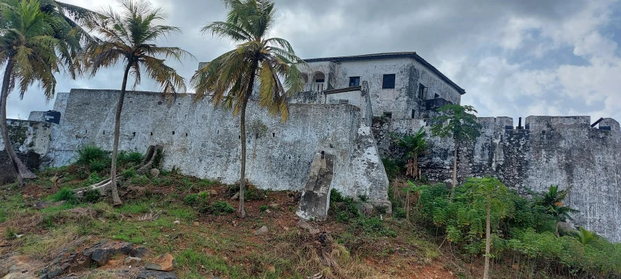
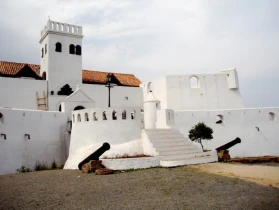
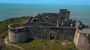
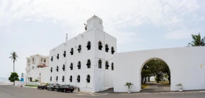
Fort Saint Anthony, also known as Forte de Santo António in Portuguese and Fort Sint Anthony in Dutch, is a historic fort near Axim, Ghana.
Constructed by the Portuguese in 1515, it was captured by the Dutch in 1642 and subsequently integrated into the Dutch Gold Coast.
The Dutch significantly expanded the fort before ceding it, along with the rest of their colony, to the British in 1872. Today, Fort Saint Anthony is owned by the Ghanaian state and is open to the public.
As the westernmost fort of the Dutch holdings, Fort Saint Anthony was the first port of call for Dutch traders, providing a place to resupply with provisions and fresh water.
It held considerable importance within the Dutch possessions, with its commandant serving as a senior commissioner in the Colonial Council in Elmina.
This council also included the commandants of Fort Nassau at Moree, Fort Crèvecoeur at Accra, and the factory at Ouidah on the Dutch Slave Coast. Unlike many other Dutch forts on the Gold Coast, Fort Saint Anthony remained continuously occupied until 1872.
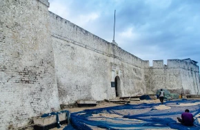
Due to its historical significance in pre-colonial and colonial trade, it was inscribed on the UNESCO World Heritage List in 1979 alongside other castles and forts in Ghana.
The early history of Fort Saint Anthony is not well-documented, largely due to the limited study of sixteenth-century Portuguese archives. However, it is believed that the Portuguese established the fort to control the local gold trade.
The first recorded Portuguese involvement near Axim dates to 1503 when the governor of Elmina requested construction materials for Captain Diogo d'Alvarenga to build the "House of Axem." After the destruction of this house by locals, the Portuguese built a new post slightly to the east, likely where Fort Saint Anthony now stands.
The commandant of Fort Saint Anthony held authority beyond the fort and Axim. After capturing the fort from the Portuguese in 1642, the Dutch signed the Treaty of Axim with local peoples, claiming joint jurisdiction over surrounding settlements.
In 1656, representatives from several local states declared their longstanding alliance and recognized the commandant’s authority over their disputes.
The Portuguese had sought to restore their dominance in the gold trade in the early 17th century by directly accessing gold sources inland.
They established a fortified outpost on the Ankobra River and a gold mine at Aboasi Hill. After taking Axim, the Dutch continued this effort but faced resistance, resulting in the destruction of Fort Ruychaver, built for controlling the gold trade.
Following the loss of its monopoly on the slave trade in 1730, the Dutch West India Company attempted to develop cotton plantations in Axim. The commandant of Fort Saint Anthony retained some jurisdiction over local states into the 19th century.
In the late 1850s, the Dutch restructured their Gold Coast possessions into districts and required detailed reports from fort commandants, then known as residents.
Julius Vitringa Coulon, the resident of Fort Saint Anthony, created a map reflecting the jurisdiction established by the Dutch decades earlier.
In 2013, the Zamani Project documented Fort Saint Anthony using 3d laser scanning. This non-profit research group from the University of Cape Town specialises in 3d digital documentation of cultural heritage sites.
The data from this project provides a permanent record for research, education, restoration, and conservation. A 3D model, panorama tour, and plans of Fort Saint Anthony are available on the Zamani Project's website.
Learn more about other colonial forts in Ghana
November 25, 2023

June 12, 2024
June 19, 2024
May 1, 2024
September 4, 2023
November 17, 2023

April 2, 2024